Crater Lake National Park Webcam: Water in Sleeping Volcano
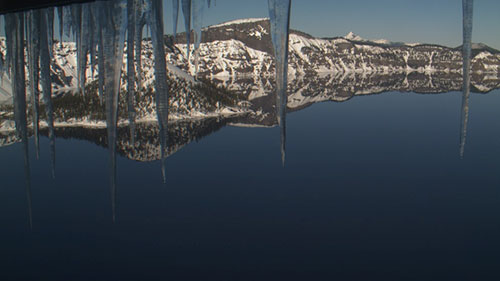
The Crater Lake National Park Webcam lets people see the lake in real time. It shows stunning views of the deep blue water, rugged cliffs, and changing weather. The National Park Service manages these cameras to help visitors plan trips and enjoy the scenery from home. Many use the webcam to check snow levels, watch the sunrise, or admire the lake’s beauty. The live feed runs year-round, making Crater Lake accessible to everyone. Even if you can’t visit in person, you can still experience its magic with just a click.
The History of Crater Lake National Park
Crater Lake National Park, located in southern Oregon, is a place of breathtaking beauty and deep historical significance. Its origins date back thousands of years, from the legends of the Klamath people to the first European settlements and its eventual designation as a national park. The park is home to Crater Lake, the deepest lake in the United States, which formed from the collapse of Mount Mazama over 7,000 years ago. The lake’s rich blue waters and dramatic cliffs have inspired awe for generations.
Indigenous History and Legends
Long before European explorers arrived, the Klamath people lived in the region surrounding Mount Mazama. According to their oral history, they witnessed the cataclysmic eruption that led to the creation of Crater Lake. Their legends tell of a fierce battle between Llao, the Chief of the Below World, and Skell, the Chief of the Above World. The battle ended when Skell defeated Llao, causing the collapse of Mount Mazama and forming the lake that we see today.
For the Klamath people, Crater Lake was a sacred place. They believed it held spiritual power and often approached it with reverence. Only select tribal members, such as medicine men or those on vision quests, were permitted to visit its shores. Their respect for the site kept it largely hidden from outsiders for centuries.
The First European Discoveries
The first known European Americans to lay eyes on Crater Lake were gold prospectors John Wesley Hillman, Henry Klippel, and Isaac Skeeters. On June 12, 1853, while searching for provisions, they stumbled upon the stunning blue waters. Struck by its vivid color, they named it “Deep Blue Lake.” However, their focus on gold mining led them to quickly move on, and their discovery was soon forgotten.
Years later, other explorers and settlers rediscovered the lake. The name “Deep Blue Lake” faded, and locals began calling it “Crater Lake” due to its volcanic origins. As interest in the lake grew, so did efforts to preserve its beauty.
William Gladstone Steel and the Push for Preservation
One of the most passionate advocates for Crater Lake was William Gladstone Steel. His fascination with the lake began in 1870 when he read about it in a newspaper. Determined to see it for himself, he visited in 1885 and was immediately captivated. Steel devoted his life to making Crater Lake a protected national park.
Working alongside geologist Clarence Dutton, Steel organized a U.S. Geological Survey (USGS) expedition in 1886 to study the lake. The team conducted detailed surveys, measuring the lake’s depth using a half-ton boat named Cleetwood. Their findings estimated the lake’s depth at 1,996 feet—remarkably close to the modern measurement of 1,949 feet.
Steel also played a major role in naming many of the lake’s landmarks, including Wizard Island, Llao Rock, and Skell Head. His relentless lobbying eventually paid off when President Theodore Roosevelt officially designated Crater Lake as a national park on May 22, 1902—making it the fifth national park in the United States.
Early Development and Tourism Growth
Once Crater Lake became a national park, efforts began to make it more accessible to visitors. Steel himself helped establish Crater Lake Lodge, which opened in 1915, offering accommodations for travelers. To make sightseeing easier, construction of Rim Drive, a scenic road encircling the lake, was completed in 1918.
By the late 1920s, new transportation routes further increased tourism. The Southern Pacific Railroad brought visitors to nearby Medford and Klamath Falls, where motor stages completed the journey to the park. Cars also became a more common way to visit, with highways connecting the park to major travel routes. In the 1929 edition of O Ranger! a publication about national parks, Crater Lake was described as a must-visit destination, with hotels, campsites, and filling stations available for visitors.
Crater Lake in Literature and Culture
The lake’s otherworldly beauty has inspired artists, writers, and poets. One notable admirer was Joaquin Miller, a poet who captured the lake’s essence in his works. Over time, Crater Lake has continued to hold a special place in American culture, attracting visitors from around the world who marvel at its brilliant blue waters and striking volcanic landscape.
Crater Lake National Park is more than just a scenic destination—it is a place of deep history, spiritual significance, and relentless conservation efforts. From the Klamath people’s legends of warring spirits to the gold prospectors’ amazement and William Gladstone Steel’s unwavering dedication, the story of Crater Lake is one of awe and perseverance. Today, millions visit each year to experience its beauty, ensuring that this natural wonder remains protected for generations to come.
Things to Do in Crater Lake National Park
Crater Lake National Park is one of the most stunning natural wonders in the United States. Located in southern Oregon, it is home to the deepest lake in the country, formed by the collapse of Mount Mazama over 7,000 years ago. The park offers breathtaking views, exciting outdoor activities, and unique geological features. Whether you enjoy hiking, fishing, camping, or scenic drives, there is something for everyone. This guide explores the best things to do at Crater Lake National Park.
Hiking Trails
Crater Lake National Park has a variety of hiking trails, ranging from easy nature walks to challenging mountain climbs. These trails offer incredible views of the lake, surrounding forests, and volcanic landscapes.
Cleetwood Cove Trail
Cleetwood Cove Trail is the only path that provides access to the lake’s shoreline. The trail is 1.1 miles long and descends 656 feet to the water. The hike down is easy, but the return trip is steep and strenuous. This trail is the starting point for boat tours and is the only location where visitors can swim in the lake.
Garfield Peak Trail
Garfield Peak Trail is a moderately difficult 1.7-mile hike. It begins east of Crater Lake Lodge and climbs about 1,000 feet. The trail offers panoramic views of the lake, Wizard Island, and the Phantom Ship rock formation. Sunset hikes are especially popular here, as the shifting colors of the lake create a stunning sight.
Mount Scott Trail
Mount Scott is the highest point in Crater Lake National Park at 8,929 feet. The trail is 2.5 miles long and fairly steep. From the summit, hikers can see over 100 miles in every direction. The view includes the entire Crater Lake caldera, the Cascade Range to the north, and the Klamath Mountains to the west.
Watchman Peak Trail
This 0.8-mile hike begins at the Watchman Overlook parking lot. The trail has a 420-foot elevation gain and offers one of the best viewpoints of Crater Lake and Wizard Island. At the summit, visitors will find a historic fire lookout tower built in 1932.
Plaikni Falls Trail
Plaikni Falls Trail is an easy 1.1-mile hike that leads to a beautiful waterfall. The trail is mostly wheelchair-accessible, except for the final uphill stretch. It starts near the Phantom Ship Overlook on Pinnacles Road and winds through a lush forest.
Castle Crest Wildflower Garden Trail
This half-mile loop trail is one of the easiest hikes in the park. It winds through a meadow filled with wildflowers during the spring and summer months. The trail is located near the park’s headquarters and is perfect for a short, scenic walk.
Scenic Drives and Viewpoints
Crater Lake is famous for its breathtaking viewpoints. The best way to explore these is by driving the Rim Drive, a 33-mile loop around the lake.
Rim Drive
Rim Drive is a must-do activity for visitors. The road follows the edge of the caldera, offering spectacular lake views from different angles. It takes about two hours to complete the drive without stopping, but many visitors take half a day to explore the viewpoints.
Discovery Point
This viewpoint is where gold prospectors first discovered Crater Lake in 1853. It offers an incredible view of the lake and surrounding landscape.
Cloudcap Overlook
At 7,960 feet, Cloudcap Overlook is the highest point on Rim Drive. From here, visitors can see across the entire caldera and beyond.
Pumice Castle Overlook
This viewpoint offers a unique look at a bright orange pumice rock formation shaped like a castle. It stands out against the surrounding gray volcanic rock.
Camping and Lodging
For those who want to stay overnight, Crater Lake National Park offers several camping and lodging options.
Mazama Campground
Mazama Campground is the largest in the park, with 214 sites for tents and RVs. It is open from June to September and offers basic amenities like restrooms, picnic tables, and fire pits.
Lost Creek Campground
This smaller campground has 16 sites and is open on a first-come, first-served basis. It is located near Pinnacles Road and is more secluded than Mazama Campground.
Crater Lake Lodge
Crater Lake Lodge is the only hotel within the park. It was built in 1915 and offers comfortable rooms with spectacular lake views. The lodge is open from late May to early October.
Fishing and Boating
Crater Lake is one of the few national parks where visitors can fish without a license.
Fishing in Crater Lake
The lake originally had no fish, but species were introduced between 1888 and 1941. Today, kokanee salmon and rainbow trout thrive in the lake. Fishing is allowed without restrictions on size, species, or number. Anglers can fish from the shore or rent a boat.
Boat Tours to Wizard Island
Boat tours run daily during the summer, offering a unique way to experience Crater Lake. The tour includes a stop at Wizard Island, a cinder cone in the middle of the lake. Visitors can hike to the top of the island, fish, or swim in the clear waters.
Swimming in Crater Lake
Swimming is allowed at Cleetwood Cove, the only lake access point. The water is extremely cold, even in summer, but many visitors enjoy the refreshing swim.
Winter Activities
Crater Lake receives heavy snowfall, making it a popular winter destination for snowshoeing and cross-country skiing.
Snowshoeing
The park offers ranger-led snowshoe hikes during the winter. These guided tours provide an educational experience while exploring the snowy landscape.
Cross-Country Skiing
Many of the park’s summer trails turn into excellent cross-country skiing routes in winter. Rim Drive, when covered in snow, becomes a scenic ski path with breathtaking lake views.
Photography and Stargazing
Crater Lake is one of the most photogenic places in the world. The deep blue water contrasts beautifully with the cliffs and surrounding forests.
Best Photography Spots
- Rim Village: Ideal for sunrise and sunset shots.
- Wizard Island Overlook: Offers a perfect view of the island.
- Cloudcap Overlook: Great for capturing the vastness of the lake.
Stargazing
Due to its remote location, Crater Lake has little light pollution, making it an excellent place for stargazing. On clear nights, visitors can see the Milky Way, planets, and countless stars.
Crater Lake National Park is a paradise for nature lovers and adventure seekers. Whether hiking to scenic viewpoints, driving along Rim Drive, fishing in the lake, or exploring in winter, there is something for everyone. The park’s stunning beauty and diverse activities make it a must-visit destination. No matter the season, Crater Lake always offers an unforgettable experience.
Geography and Climate
Crater Lake National Park, located in southern Oregon, is one of the most geologically fascinating and climatically extreme areas in the United States. Formed by a massive volcanic eruption, the park features diverse landscapes, including towering peaks, deep canyons, rugged plateaus, and one of the purest lakes in the world. It experiences heavy snowfall, cool summers, and unique soil conditions that shape its ecosystems.
This article explores the geography and climate of Crater Lake National Park, covering volcanic formations, landforms, weather patterns, and seasonal changes.
The Volcanic Origins of Crater Lake
Crater Lake National Park is part of the Cascade Range, a volcanic mountain chain formed by subduction of the Juan de Fuca Plate beneath the North American Plate. The heat and pressure from this movement have produced a series of volcanoes, known as the High Cascades, including Mount Mazama, which once stood where Crater Lake exists today.
The Formation and Collapse of Mount Mazama
Mount Mazama began forming around 400,000 years ago as a stratovolcano, growing through multiple eruptions that layered lava and ash. The mountain eventually reached a height of 11,000 feet (3,400 m). Over time, smaller volcanic vents and cinder cones formed around its base.
However, around 7,700 years ago, Mount Mazama erupted violently. This eruption was one of the most explosive events in North America, sending ash as far as Yellowstone National Park, British Columbia, and Nevada. The explosion was 150 times more powerful than the 1980 eruption of Mount St. Helens.
As the volcano emptied its magma chamber, the summit collapsed, forming a caldera nearly 5 miles (8 km) wide. Over centuries, the caldera filled with rain and snowmelt, forming Crater Lake.
Notable Landforms in Crater Lake National Park
Crater Lake National Park contains unique geological features formed by volcanic activity, erosion, and time.
The Pinnacles
The Pinnacles are towering spires of rock, formed when hot ash and pumice settled near the volcano. Over time, hot gas escaping through the deposits hardened the surrounding material, creating cemented volcanic columns. Erosion later removed the softer ash, leaving behind these striking pinnacles.
The Pumice Desert
The Pumice Desert stretches northward from Mount Mazama and consists of a thick layer of pumice and volcanic ash. Even after thousands of years, this barren landscape remains largely plant-free due to its high porosity, which causes water to drain too quickly for vegetation to thrive.
Mount Scott
At 8,929 feet (2,722 m), Mount Scott is the highest peak in the park. This steep andesitic cone formed from Mount Mazama’s magma chamber. Scientists classify it as a parasitic cone, meaning it was an offshoot of the larger volcano. Unlike Mount Mazama, Mount Scott ceased erupting before the end of the Pleistocene Epoch. Today, it features a large glacial cirque on its northwest side.
Union Peak
Located in the southwest corner of the park, Union Peak is an extinct volcano that has been heavily eroded. What remains today is a volcanic plug, formed when lava solidified within the volcano’s neck.
Crater Peak
Crater Peak is a shield volcano, composed mainly of andesite and basalt lava flows. Its summit features a layer of andesitic and dacite tephra, indicating past explosive activity.
Timber Crater
Situated in the northeast corner of the park, Timber Crater is another shield volcano. Like Crater Peak, it is made of basaltic and andesitic lava flows but is unique for having two cinder cones at its summit.
Llao Rock
Llao Rock is one of the tallest cliffs around Crater Lake, rising 1,800 feet (550 m) above the water. A 1.3-mile (2.1 km) trail from Rim Drive leads to the summit, providing one of the best panoramic views of the lake and surrounding mountains.
Rim Drive and Other Scenic Routes
The best way to experience the park’s diverse geography is by driving along Rim Drive, a 33-mile (53 km) scenic road that circles the lake.
Rim Drive
- The most popular scenic route in the park.
- Provides breathtaking views of Crater Lake, Wizard Island, and surrounding peaks.
- Elevation gain of 3,800 feet (1,200 m).
- Open July to October, depending on snow conditions.
The Pacific Crest Trail
The Pacific Crest Trail (PCT), a 2,650-mile (4,260 km) hiking route from Mexico to Canada, passes through Crater Lake National Park. This section offers stunning views of the lake and surrounding forests.
Climate of Crater Lake National Park
Crater Lake National Park has a dry-summer subarctic climate (Dsc). It experiences long, snowy winters and short, mild summers.
Snowfall and Winter Conditions
Crater Lake receives some of the heaviest snowfall in North America, with an average of 463 inches (1,180 cm) annually.
- Highest snowfall records:
- 37 inches (94 cm) in one day (1937, 1951, 1971).
- 313 inches (800 cm) in one month (January 1950).
- 903 inches (2,290 cm) in one year (1950).
Because of the high snowfall, roads and trails remain buried under snow until late spring.
Seasonal Changes
Winter (November–April)
- Temperatures drop below freezing.
- Heavy snowfall covers most of the park.
- December is the coldest month, with average highs of 33°F (1°C) and lows of 19°F (−7°C).
Spring (May–June)
- Snow starts melting, but some drifts last until July.
- Roads begin to reopen.
- Wildflowers bloom in lower elevations.
Summer (July–September)
- August is the warmest month, with highs around 69°F (21°C) and lows around 42°F (6°C).
- Most of the park is accessible, and Rim Drive opens.
- Snow is uncommon, and clear skies dominate.
Fall (October–November)
- Early snowstorms can begin in October.
- Temperatures drop, and trails start closing.
- Visibility remains high, but conditions change rapidly.
Precipitation and Lake Freezing
Crater Lake rarely freezes completely due to its depth and heat retention.
- The last full freeze occurred in 1949.
- The most recent partial freeze (95%) happened in 1985.
The lake maintains an average surface temperature of 55°F (13°C) in summer and 38°F (3°C) at the bottom year-round.
Forests and Vegetation
Despite its volcanic origins, Crater Lake National Park is home to 50,000 acres (202.3 km²) of old-growth forests.
- Lower elevations: Ponderosa pines, lodgepole pines, and white fir.
- Higher elevations: Mountain hemlock and subalpine fir.
- The Pumice Desert: Mostly barren due to poor soil quality.
Crater Lake National Park is a geological and climatic wonder. The park’s dramatic landscape was shaped by volcanic eruptions, glacial activity, and erosion. Its climate is harsh and snowy, making it one of the snowiest places in North America.
Whether you’re exploring the Pumice Desert, hiking Mount Scott, or driving along Rim Drive, Crater Lake offers breathtaking views and unique natural features. The park’s volcanic history and extreme climate make it one of the most fascinating destinations in the United States.
Wizard Island: The Volcanic Gem of Crater Lake
Wizard Island is a striking volcanic cinder cone that rises from the deep blue waters of Crater Lake in Crater Lake National Park, Oregon. Located on the west end of the lake, this island is a fascinating geological feature and a popular destination for visitors. It reaches an elevation of 6,933 feet (2,113 m) above sea level, standing about 755 feet (230 m) above the lake’s surface.
Formed after the violent eruption of Mount Mazama around 7,700 years ago, Wizard Island is one of the most visible reminders of the park’s explosive past. Today, it attracts hikers, photographers, and nature lovers who want to experience its rugged beauty and incredible views.
The Formation of Wizard Island
Wizard Island was created after Mount Mazama erupted and collapsed, leaving behind a massive caldera that later filled with water to form Crater Lake. After the main eruption, a series of smaller volcanic eruptions occurred inside the caldera. These eruptions built up several cinder cones on the caldera floor.
The largest of these cones, and the only one to rise above the lake’s surface, is Wizard Island. It rises over 2,700 feet (820 m) above the lowest point on the caldera floor and the deepest point in the lake.
Another cinder cone, known as Merriam Cone, is located in the northeast part of the lake. Although it rises 1,400 feet (430 m) above the caldera floor, it remains 505 feet (154 m) below the lake’s surface. Unlike Wizard Island, Merriam Cone formed underwater, giving it a smoother surface and no visible crater.
The Witches Cauldron: A Crater at the Summit
At the top of Wizard Island, there is a volcanic crater about 500 feet (150 m) wide and 100 feet (30 m) deep. This crater, named the “Witches Cauldron,” was given its name by William Gladstone Steel in 1885. Steel, a key figure in the creation of Crater Lake National Park, also named Wizard Island.
The crater was formed during the final stages of the island’s volcanic eruptions. Over time, erosion and weathering have softened its features, but the depression remains clearly visible.
Exploring Wizard Island
Wizard Island is one of the most exciting places to visit in Crater Lake National Park. It covers 315.85 acres (127.82 ha) and offers incredible hiking, sightseeing, and fishing opportunities.
Boat Tours and Access
Visitors can reach Wizard Island by taking a boat tour from Cleetwood Cove. These tours operate daily during the summer and allow visitors to hike, explore, and even swim in the lake. Since there are no roads leading to the island, boat access is the only way to visit.
Hiking the Wizard Island Summit Trail
The Wizard Island Summit Trail is the main hike on the island. It is a steep, 2.2-mile round-trip trail that leads to the summit, where visitors can look down into the Witches Cauldron and enjoy panoramic views of Crater Lake.
- Trail Length: 2.2 miles round trip
- Elevation Gain: About 750 feet
- Difficulty: Moderate to strenuous
The hike offers stunning views of the lake’s deep blue waters, steep cliffs, and surrounding peaks. The trail is well-marked but can be challenging due to its steep incline and loose volcanic rock.
Fishing and Swimming
Fishing is allowed in Crater Lake without a license, and Wizard Island is a popular spot for anglers. The lake contains kokanee salmon and rainbow trout, both of which were introduced between 1888 and 1941. Since the water is crystal clear, visitors can often see the fish swimming beneath the surface.
Swimming is also permitted near the island. However, the water is extremely cold, even in summer, due to the lake’s depth and high elevation.
The Beauty of Wizard Island
Wizard Island is one of the most iconic landmarks in Crater Lake National Park. Its dark volcanic rock contrasts beautifully with the lake’s brilliant blue waters. From the top, visitors can take in breathtaking views of the entire caldera, Rim Drive, and the distant Cascade peaks.
Because it formed so recently in geological terms, the island still retains its raw volcanic appearance. Its rugged slopes, sparse vegetation, and cratered summit make it feel like a landscape from another world.
Conclusion
Wizard Island is a fascinating volcanic feature and a must-visit destination within Crater Lake National Park. Formed after the collapse of Mount Mazama, this cinder cone tells the story of the park’s fiery past.
Whether hiking to the Witches Cauldron, fishing in the pristine waters, or simply enjoying the incredible views, visitors to Wizard Island will experience one of the most unique and beautiful places in the United States.


