Mt Rainier Paradise Webcam: Highest Peak in WA State
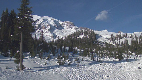
The Mt Rainier Paradise Webcam offers a stunning glimpse into one of America’s most breathtaking national parks. Located at 5,400 feet near the Paradise Jackson Visitor Center, the webcam provides real-time views of Mount Rainier’s majestic southern slopes and the surrounding Paradise Valley.
This webcam showcases Mount Rainier’s beauty throughout the year. During winter, you can watch the snow pile up in one of the snowiest places on Earth, where annual snowfall often exceeds 50 feet. The scenes of snow-covered trees and icy landscapes are mesmerizing.
The Rich History of Mount Rainier
Mount Rainier, a towering stratovolcano in the Cascade Range, has been an iconic landmark for thousands of years. Its history is deeply intertwined with the Indigenous peoples who first inhabited the area, European explorers who named it, and the efforts to preserve its natural beauty. This article delves into the rich history of Mount Rainier, from its earliest human settlements to its designation as a national park.
Early Indigenous Inhabitants of Mount Rainier
Natives and Their Connection to the Mountain
For over 8,500 years, Indigenous peoples have lived in and around the Mount Rainier region. Several indigenous groups, including the Nisqually, Cowlitz, Puyallup, Yakama, and Muckleshoot, have long revered the mountain as a sacred place. These natives relied on the region’s forests and meadows for hunting, fishing, and gathering plants for food and medicine.
Seasonal Migration and Resource Use
Archaeological evidence suggests that Indigenous groups used the mountain seasonally, establishing camps in its subalpine meadows during the summer months. They used controlled burns to maintain open meadows, encouraging plant growth for food and attracting game. Stone tools, fire pits, and other artifacts found in the region confirm their long-standing presence.
Mythology and Spiritual Significance
Mount Rainier, known as Tahoma or Tacoma to local groups, played a central role in their mythology. Many stories depict the mountain as a powerful spirit or guardian of the land. Some legends tell of great floods and battles between deities that shaped the region’s landscape.
The Arrival of European Explorers
Spanish and British Expeditions
The first Europeans to reach the Pacific Northwest were the Spanish, who arrived by sea in 1774, led by Juan Pérez. They may have seen Mount Rainier from offshore, though no written records confirm this. The British explorer Captain James Cook sailed along the coast in 1778, sparking interest in the region’s fur trade.
Captain George Vancouver and the Naming of Mount Rainier
On May 7, 1792, Captain George Vancouver and his expedition became the first Europeans to document a sighting of the mountain. The following day, Vancouver named the peak Mount Rainier in honor of his friend, Rear Admiral Peter Rainier of the British Royal Navy.
The Lewis and Clark Expedition
Although Meriwether Lewis and William Clark did not explore Mount Rainier directly, they observed it during their journey to the Pacific in 1806. Their expedition helped increase American interest in the Pacific Northwest.
Territorial Claims and Settler Expansion
International Disputes Over the Region
In the early 19th century, several nations, including Spain, Russia, Britain, and the United States, laid claim to the Pacific Northwest. Treaties gradually defined borders:
- 1818: The U.S. and Britain agreed to jointly occupy the Oregon Country.
- 1824: Russia ceded its claims south of the 54°40′ latitude.
- 1846: The Oregon Treaty established the U.S.-Canada border along the 49th parallel, securing Mount Rainier within American territory.
- 1853: The Washington Territory was established, covering modern-day Washington state.
Early Exploration and Climbing Expeditions
In 1833, Scottish botanist William Fraser Tolmie explored Mount Rainier in search of medicinal plants. In 1870, climbers Hazard Stevens and P.B. Van Trump became the first people known to have successfully reached the summit. Their achievement was celebrated in Olympia, Washington, marking the beginning of mountaineering in the region.
The First Woman to Climb Mount Rainier
In 1890, Fay Fuller became the first woman to summit Mount Rainier. Her accomplishment inspired future generations of female climbers and adventurers.
The Birth of Mount Rainier National Park
John Muir’s Influence and Early Conservation Efforts
Naturalist John Muir climbed Mount Rainier in 1888 and became a strong advocate for its preservation. He and other conservationists pushed for the creation of a national park to protect the mountain’s forests and glaciers from logging and development.
Establishment of the National Park in 1899
On March 2, 1899, President William McKinley signed a bill establishing Mount Rainier National Park, making it the fifth national park in the United States. The park was created “for the benefit and enjoyment of the people” and to protect the area’s natural wonders.
Development and Tourism in the 20th Century
James Longmire and the Creation of a Resort
In 1883, explorer James Longmire discovered a mineral spring while descending from Mount Rainier. He later established a spa and hotel, attracting visitors seeking the spring’s healing properties. Today, Longmire remains one of the most popular destinations in the park.
The Rise of Mountaineering and Recreation
Throughout the 20th century, Mount Rainier became a major destination for hikers, climbers, and skiers. The construction of roads and trails made the park more accessible, and Paradise Lodge, built in 1916, became a popular retreat.
Mount Rainier’s Role in Aviation and Pop Culture
The Birthplace of the “Flying Saucer” Phenomenon
On June 24, 1947, pilot Kenneth Arnold reported seeing a formation of unidentified flying objects (UFOs) near Mount Rainier. His description of the objects as moving like “saucers skipping on water” led to the coining of the term “flying saucer” and sparked widespread interest in UFOs.
Mount Rainier on Stamps and Currency
Mount Rainier has appeared on several U.S. postage stamps, including a 3-cent National Park series stamp in 1934. It is also featured on the Washington state quarter, released in 2007, alongside a leaping salmon.
Mount Rainier’s Volcanic Hazards and Modern Monitoring
The Risk of Lahars and Eruptions
As an active volcano, Mount Rainier poses a significant hazard to nearby communities. The greatest threat comes from lahars, massive volcanic mudflows that could devastate towns along the Puyallup River valley.
Lahar Warning System and Emergency Preparedness
In 1998, the U.S. Geological Survey (USGS) implemented the Mount Rainier Volcano Lahar Warning System to help evacuate residents in case of an eruption. This system is now operated by the Pierce County Department of Emergency Management.
Mount Rainier has played a significant role in Indigenous cultures, European exploration, territorial disputes, and American conservation efforts. Its designation as a national park helped preserve its majestic landscapes, and it remains a symbol of natural beauty and adventure.
Despite its volcanic risks, Mount Rainier continues to be a beloved destination for hikers, climbers, and nature lovers. Its rich history and breathtaking scenery ensure that it will be cherished for generations to come.
The Geography of Mount Rainier
Mount Rainier is the tallest mountain in Washington State and the entire Cascade Range. Standing at 14,410 feet (4,392 meters), it dominates the skyline and can be seen from miles away. Its rugged terrain, vast glaciers, and volcanic origins make it one of the most fascinating mountains in North America.
Location and Topography
Where Is Mount Rainier?
Mount Rainier is located southeast of Tacoma, about 60 miles (97 km) south-southeast of Seattle. It is part of Mount Rainier National Park, a protected area known for its stunning alpine scenery, deep valleys, and lush forests.
Topographic Prominence and Visibility
With a topographic prominence of 13,210 feet (4,026 meters), Mount Rainier is one of the most prominent peaks in the United States. On clear days, people from the Seattle-Tacoma metropolitan area refer to it simply as “the Mountain” because of its towering presence. In exceptional weather conditions, it can be seen from as far as Corvallis, Oregon, and even the North Shore Mountains in British Columbia.
Glaciers and Snowfields
The Most Glaciated Peak in the Lower 48 States
Mount Rainier has 26 major glaciers and around 36 square miles (93 km²) of permanent snowfields and glaciers. This makes it the most heavily glaciated peak in the contiguous United States.
Summit Craters and Ice Caves
The summit contains two volcanic craters, each over 1,000 feet (300 meters) in diameter. The larger east crater overlaps the west crater. Due to geothermal heat, parts of the crater rims remain free of snow and ice year-round.
Inside the craters lies the world’s largest volcanic glacier cave system, with nearly 2 miles (3.2 km) of ice passages. A small crater lake, about 130 feet (40 meters) long and 16 feet (5 meters) deep, sits at 14,203 feet (4,329 meters), making it the highest lake in North America.
Rivers and Water Sources
Major Rivers That Originate From Mount Rainier
Mount Rainier’s glaciers feed several major rivers in Washington State:
- Carbon River
- Cowlitz River
- Nisqually River
- Puyallup River
- North Mowich River
- White River
The White River’s sources include the Winthrop, Emmons, and Fryingpan Glaciers. The Puyallup River, fed by multiple glaciers, eventually empties into Commencement Bay at Tacoma. The Nisqually River flows into Puget Sound, and the Cowlitz River joins the Columbia River between Kelso and Longview.
Summits and Peaks
The Three Main Summits
Mount Rainier’s broad summit includes three named peaks:
- Columbia Crest – The highest point at 14,410 feet (4,392 meters).
- Point Success – A secondary peak at 14,158 feet (4,315 meters), located on the southern edge of the summit plateau.
- Liberty Cap – The lowest of the three, standing at 14,112 feet (4,301 meters). It overlooks Liberty Ridge, the Sunset Amphitheater, and Willis Wall.
Little Tahoma Peak: A Distinct Summit
On the eastern side of Mount Rainier, Little Tahoma Peak rises to 11,138 feet (3,395 meters). It is a remnant of an older, much larger version of Mount Rainier that has since eroded away. Although it is part of the same volcanic structure, climbers usually consider Little Tahoma a separate peak. If classified separately, it would be the third-highest peak in Washington State.
Elevation and Official Measurements
How High Is Mount Rainier?
The official elevation of Mount Rainier is 14,410 feet (4,392 meters) at Columbia Crest. This measurement was first taken in 1956 and is based on the National Geodetic Vertical Datum of 1929.
Another commonly cited elevation is 14,411 feet (4,392 meters), based on the National Geodetic Vertical Datum of 1988. Although the difference is slight, both figures are widely accepted.
Mount Rainier’s geography is as complex as it is breathtaking. With its towering prominence, massive glaciers, and active volcanic features, it remains one of the most geologically and visually striking mountains in the world. Whether viewed from Seattle’s skyline or explored up close, Mount Rainier stands as a natural wonder and a symbol of the Pacific Northwest.
The Geology of Mount Rainier
Mount Rainier is a stratovolcano in the Cascade Volcanic Arc, shaped by volcanic eruptions, lava flows, and massive debris avalanches. With a towering height of 14,410 feet (4,392 meters), it is the highest peak in Washington State and one of the most dangerous volcanoes in North America. Its geological history spans hundreds of thousands of years, revealing a story of eruptions, collapses, and glacial activity.
Formation and Early Volcanic History
Origins of Mount Rainier
The volcanic activity that formed Mount Rainier began over 840,000 years ago, during the period known as the Lily Formation (which lasted from 2.9 million to 840,000 years ago). Before the current peak formed, a proto-Rainier—an ancestral cone—existed. Over time, volcanic eruptions built the modern summit cone, which is estimated to be more than 500,000 years old.
Volcanic Composition
Mount Rainier is made mostly of andesite, a volcanic rock that results from lava flows and explosive eruptions. The mountain is highly eroded, primarily due to the glaciers that cover its slopes. Over thousands of years, these glaciers have carved deep valleys and left behind layers of tephra, ash, and lava deposits.
Major Geological Events
The Osceola Mudflow: A Catastrophic Collapse
Approximately 5,000 years ago, a massive debris avalanche removed about 1,600 feet (500 meters) from the summit of Mount Rainier. This event triggered the Osceola Mudflow, a colossal lahar (volcanic mudflow) that traveled over 30 miles (48 km) and reached the present-day locations of Tacoma and southern Seattle.
The Electron Mudflow
Around 530 to 550 years ago, another lahar event, known as the Electron Mudflow, occurred. Though smaller than the Osceola Mudflow, it still reshaped river valleys and deposited thick layers of volcanic material.
Recent Eruptive History
After the major collapse 5,000 years ago, new eruptions gradually rebuilt the summit cone. Some of the most recent activity includes:
- Holocene eruptions: As many as 11 layers of tephra have been found, with eruptions occurring over the past 10,000 years.
- Eruptions from 1820 to 1854: The most recent confirmed eruptions occurred during this period, with eyewitness reports of activity in 1858, 1870, 1879, 1882, and 1894.
- Last recorded eruption (1450 CE): According to the Smithsonian Institution’s Global Volcanism Program, Mount Rainier last erupted around 1450 CE.
Seismic and Volcanic Monitoring
Mount Rainier experiences regular seismic activity, including earthquakes and tremors. Typically, about five small earthquakes occur each month near the summit. Occasionally, seismic swarms take place, with clusters of earthquakes over several days.
Scientists monitor the mountain using seismic sensors, which can detect signs of magma movement or an impending eruption. These sensors are part of the Mount Rainier Volcano Lahar Warning System, which has been in place since 1998.
The Pacific Ring of Fire and the Cascade Volcanic Arc
Mount Rainier is part of the Pacific Ring of Fire, a region with some of the most active volcanoes on Earth. Other major volcanoes in the Cascade Volcanic Arc include:
- Mount St. Helens (erupted in 1980 and 2004)
- Mount Hood in Oregon
- Mount Baker in Washington
- Crater Lake (formerly Mount Mazama) in Oregon
Geological Hazards
Lahars: The Greatest Threat
The biggest danger from Mount Rainier is lahars, or volcanic mudflows. With large glaciers covering the peak, an eruption or even a small collapse could send massive flows of mud, rock, and ice into nearby valleys.
Lahar Risk and Impact
- The Puyallup, Carbon, and White Rivers are all susceptible to lahars.
- More than 150,000 people live on old lahar deposits from past eruptions.
- A repeat of the Osceola Mudflow could destroy cities like Enumclaw, Orting, Kent, Auburn, Puyallup, Sumner, and Renton.
- A major mudflow could even reach downtown Seattle and trigger tsunamis in Puget Sound and Lake Washington.
Pyroclastic Flows and Lava Flows
Although lava flows are not the primary hazard, pyroclastic flows—fast-moving clouds of hot gas and volcanic debris—could wipe out entire communities in minutes.
Hydrothermal Activity and Structural Weakness
Mount Rainier is slowly being weakened by hydrothermal activity. Heat and acidic gases from the volcano interact with rock, making some sections of the mountain unstable. This increases the likelihood of future collapses and lahars, even without an eruption.
Economic Impact of a Major Eruption
A 2012 report from the Washington State Department of Natural Resources estimated that a major lahar could cause up to $40 billion in damage. Infrastructure such as bridges, highways, and power lines could be severely affected.
Glaciers and Their Role in Erosion
Glaciers on Mount Rainier
Mount Rainier is home to 29 named glaciers, covering about 30.41 square miles (78.8 km²). These glaciers are among the most important sources of water for rivers that provide hydroelectric power and irrigation.
Retreat and Changes Over Time
Glaciers on Mount Rainier have advanced and retreated multiple times:
- During the last Ice Age (25,000–15,000 years ago), glaciers covered most of the region.
- During the Little Ice Age (14th–19th century), glaciers extended farther down the valleys.
- Since the early 20th century, glaciers have been retreating rapidly due to climate change.
Recent Glacier Loss
Between 2015 and 2022, Mount Rainier’s glaciers saw significant shrinking and volume loss. Some smaller glaciers, like Stevens, Pyramid, and Van Trump, have disappeared entirely.
Lahar Warning Systems and Evacuation Plans
The Mount Rainier Volcano Lahar Warning System was installed in 1998 to provide early warnings. Pierce County maintains the system, which includes sirens, sensors, and escape route signs.
Emergency Preparedness Drills
To prepare for potential lahars, local authorities conduct annual evacuation drills. In 2024, a drill included 45,000 students and staff from school districts in Puyallup, Sumner–Bonney Lake, Orting, White River, and Carbonado. These exercises help ensure that communities can evacuate quickly in an emergency.
Mount Rainier’s geological history is marked by massive eruptions, destructive mudflows, and constant seismic activity. While it is one of the most beautiful and iconic mountains in the U.S., it is also one of the most dangerous volcanoes in the world.
With advanced monitoring systems, emergency drills, and public awareness, scientists and local governments are working to reduce the risks associated with this towering giant. However, the possibility of a future eruption or major lahar event remains a serious concern for those living in its shadow.
The Ecology of Mount Rainier
Mount Rainier’s protected status as a national park helps preserve its rich and diverse ecosystem. The mountain’s varied elevations and climates support a wide range of plants, animals, and fungi. Some species, like the Cascade red fox and Mount Rainier lousewort, are found nowhere else in the world. From towering old-growth forests to vibrant wildflower meadows, the mountain offers one of the most pristine natural habitats in the Pacific Northwest.
Distinct Ecological Zones
The Forest Zone: A Lush Green Wonderland
At lower elevations, Mount Rainier is covered in dense forests that range in age from 100 years to over 1,000 years old. The dominant trees include:
- Western red cedar
- Douglas fir
- Western hemlock
As elevation increases, different species take over, such as:
- Pacific silver fir
- Western white pine
- Alaska yellow cedar
- Noble fir
These forests provide essential habitats for mammals, birds, and amphibians, offering shelter and food sources year-round.
The Subalpine Zone: Home of the Wildflowers
Higher up the mountain, the subalpine zone is marked by open meadows and scattered trees. Snow covers the ground well into summer, creating a short but dramatic growing season for plants.
One of the most famous areas for wildflowers is Paradise, where visitors can see spectacular blooms of:
- Lupines
- Indian paintbrush
- Avalanche lilies
- Pasqueflowers
In 1924, naturalist Floyd W. Schmoe described Mount Rainier National Park as being world-famous for its wildflowers, more than for any other natural feature.
The Alpine Zone: Life at the Edge
Above the tree line, the alpine zone begins. The environment here is harsh, with strong winds, rocky terrain, and little vegetation. Only the hardiest plants, like mosses and lichens, can survive in these conditions. Subalpine fir and mountain hemlock are among the few trees that can grow at these elevations.
Despite the extreme conditions, some animals manage to thrive, including pikas, mountain goats, and marmots.
Wildlife on Mount Rainier
Mammals: From Large Predators to Small Creatures
Mount Rainier is home to 65 species of mammals, ranging from large predators to small rodents. Some of the most commonly spotted animals include:
- Mountain goats – Expert climbers that navigate the steep cliffs.
- Cougars – Stealthy hunters that roam the forested slopes.
- Black bears – Foragers that thrive in the park’s wilderness.
- Marmots – Large, furry rodents often seen sunbathing on rocks.
- Elk and deer – Herbivores that migrate between forested and open areas.
Efforts are underway to reintroduce species that were once locally extinct, such as the Pacific fisher, a small carnivorous mammal that was historically hunted for its fur.
Birds: A Haven for Year-Round and Migratory Species
Mount Rainier provides shelter to 182 species of birds. Some are permanent residents, while others migrate seasonally. Notable species include:
- Northern spotted owl – A federally protected species.
- Peregrine falcon – One of the fastest birds in the world.
- Bald eagle – A symbol of American wilderness.
- Gray jays and Clark’s nutcrackers – Known for their intelligence and ability to store food.
Many birds nest in the old-growth forests, while others soar high in the alpine zone, hunting for prey or scavenging for food.
Reptiles and Amphibians: Small but Important
Although reptiles are less common in the cool, damp climate of Mount Rainier, a few species can be found:
- Common garter snakes
- Northern alligator lizards
Amphibians, however, thrive in the park’s wet environment. Species such as frogs, toads, and salamanders are abundant in streams, ponds, and moist forest floors.
Fish: Surviving in Glacier-Fed Rivers
Mount Rainier’s rivers and lakes support 14 species of native fish, including:
- Salmon – Known for their long migrations.
- Trout – Found in cold mountain streams.
Although the stocking of fish ended in 1972, some reproducing populations remain in at least 30 lakes. These fish play a crucial role in the aquatic ecosystem and provide food for birds and mammals.
Ecological Conservation and Threats
Protecting Endangered Species
Several species on Mount Rainier are protected at the state or federal level due to declining populations. Conservation efforts focus on:
- Preserving habitats
- Monitoring wildlife populations
- Preventing the introduction of invasive species
Climate Change and Its Impact
Climate change is one of the biggest threats to Mount Rainier’s ecosystem. Rising temperatures are causing:
- Glacier retreat, affecting water sources for fish and wildlife.
- Longer dry seasons, increasing the risk of wildfires.
- Shifts in plant and animal populations, as species struggle to adapt.
Human Impact and Preservation Efforts
To protect Mount Rainier’s fragile ecosystem, the National Park Service enforces strict conservation policies, including:
- Limiting development and human activity in sensitive areas.
- Educating visitors about the importance of preserving the environment.
- Conducting scientific research to track changes in biodiversity.
Mount Rainier’s ecology is incredibly diverse, with habitats ranging from old-growth forests to high-altitude tundra. Its wildlife and plant life create one of the most stunning and biologically rich environments in the Pacific Northwest.
Through continued conservation efforts, scientists and park rangers are working to protect this unique ecosystem for future generations. Whether exploring its wildflower meadows, spotting a mountain goat on a rocky slope, or listening to the call of an owl in the dense forest, Mount Rainier remains an invaluable treasure of nature.


